Our Severe Weather Threats This Week
Unleash Your Creative Genius with MuseMind: Your AI-Powered Content Creation Copilot. Try now! 🚀
It's Monday morning, and I hope you all had a fantastic weekend. We had some pretty good weather over the weekend, so no big complaints there. However, we did experience a big severe weather event last week, and as we're in severe weather season, we can expect more chances for severe weather just about every week for the next several weeks.
Before we dive into this week's forecast, I want to give a huge shout out to Superior Roofing and Construction. They are a four-state premier roofing contractor, family-owned and operated right here in Joplin, Missouri. They did an excellent job on my roof last fall, right during severe weather season. So, if you ever need any roofing work done, make sure to keep them in mind. Their contact information is right there on the screen.
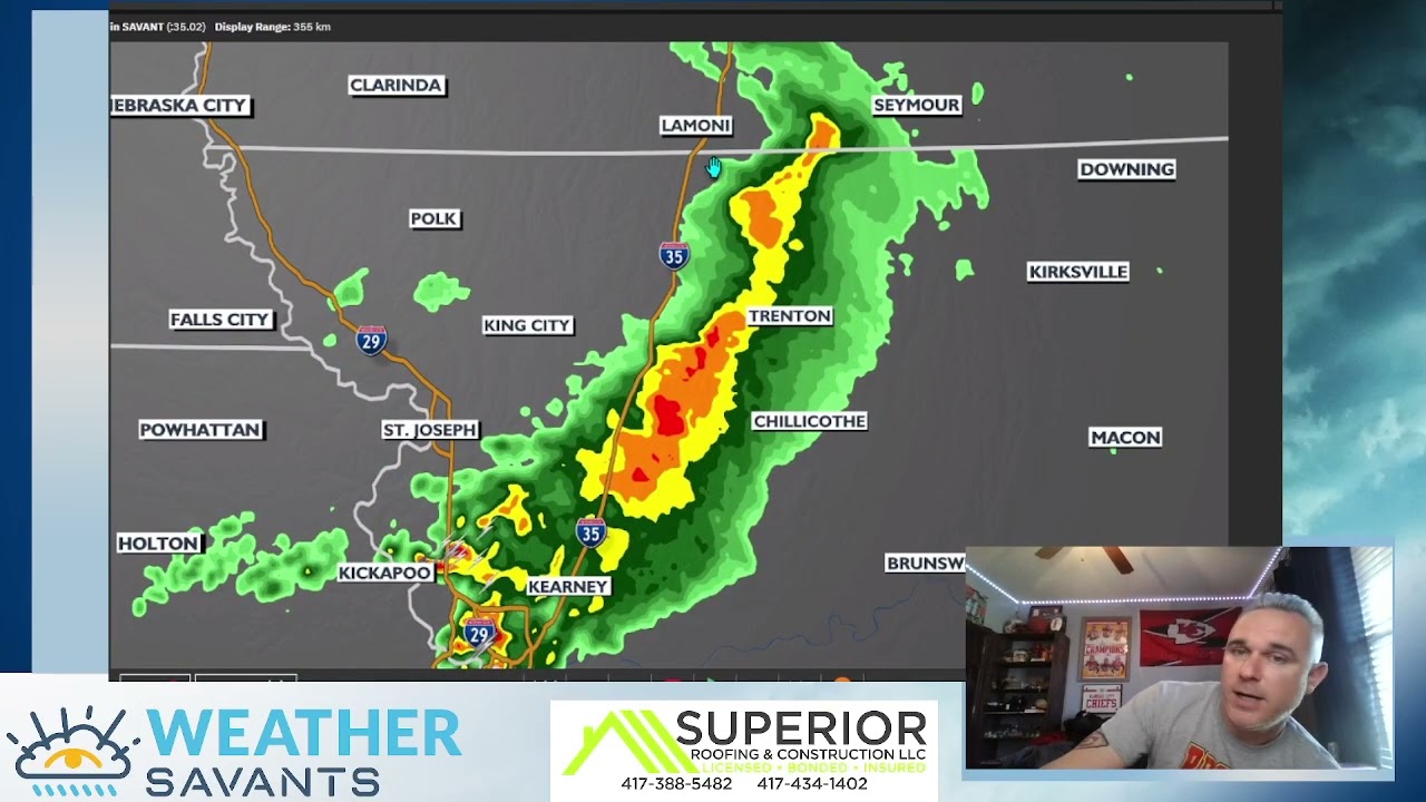
Now, let's take a look at what's happening with the weather right now. We have some showers and thunderstorms to our north, around Kansas City. They're not too strong, but they are dropping some decent amounts of rain. So, if you're in St. Joe or the north side of Kansas City, expect some wet weather. These showers and thunderstorms are moving through the region, and there are already a few showers popping up in Garnett, Iola, Mount City, and Burlington. These will continue to expand as we go into the afternoon. Once our atmosphere becomes more unstable, we could see some stronger thunderstorms trying to develop later today in Southeast Kansas and the northern parts of Oklahoma.
Thunderstorms Today, Beautiful Weather Tomorrow and Wednesday
As we move through the day, the storms near Kansas City will start to fall apart. However, from Topeka all the way down through Southeastern Kansas, we can expect more showers and thunderstorms to pop up later on today. These storms will stretch all the way from north of Tulsa to north of Oklahoma City. While they are not expected to be severe, we can't rule out a couple of strong thunderstorms trying to get going. Once we lose the heating of the day, these storms will start to die down by around 9:00 p.m.
But don't worry, after today's thunderstorms, we are in for a pretty nice stretch of weather. Tomorrow, expect temperatures of 78 in Kansas City, 80 in Celina, 75 in Oklahoma City, and 75 in Fort Smith. Wednesday looks great as well, with temperatures in the mid-70s to near 80 in central and western parts of Kansas. It may be a little windy, but that won't stop us from enjoying the beautiful weather.
Another Severe Weather Threat on Friday
Now, let's talk about our next storm system. It's coming in a day or two late, thanks to a cutoff low across parts of the southeastern US. This cutoff low is kind of clogging up the system, but it still fits the pattern perfectly. On Friday, we can expect showers and thunderstorms with a higher risk of severe weather. This storm system will affect eastern Kansas, western Missouri, and northeastern parts of Oklahoma. So, be prepared for a severe weather threat on Friday afternoon into Friday evening. By Saturday, the system will slide further east, and any severe threat will mainly be in Illinois, down toward Memphis, and eastern parts of Arkansas. Most of our region will start to clear out as we head into the weekend.
So, to sum it up, we have two thunderstorm threats this week. The first one is today, with the possibility of a random isolated severe thunderstorm warning. It's going to be a pretty good week overall, but we need to keep an eye out for the storm system moving in on Friday, which will give us another severe weather threat.
Tomorrow or on Wednesday, I will do a long-range forecast and break down the rest of the month of April. We'll also start to look into May as well. If you have any comments or questions, leave them in the comment section below. Have a great Monday, folks!